Skip to content Skip to footer

Cavagrande del Cassibile

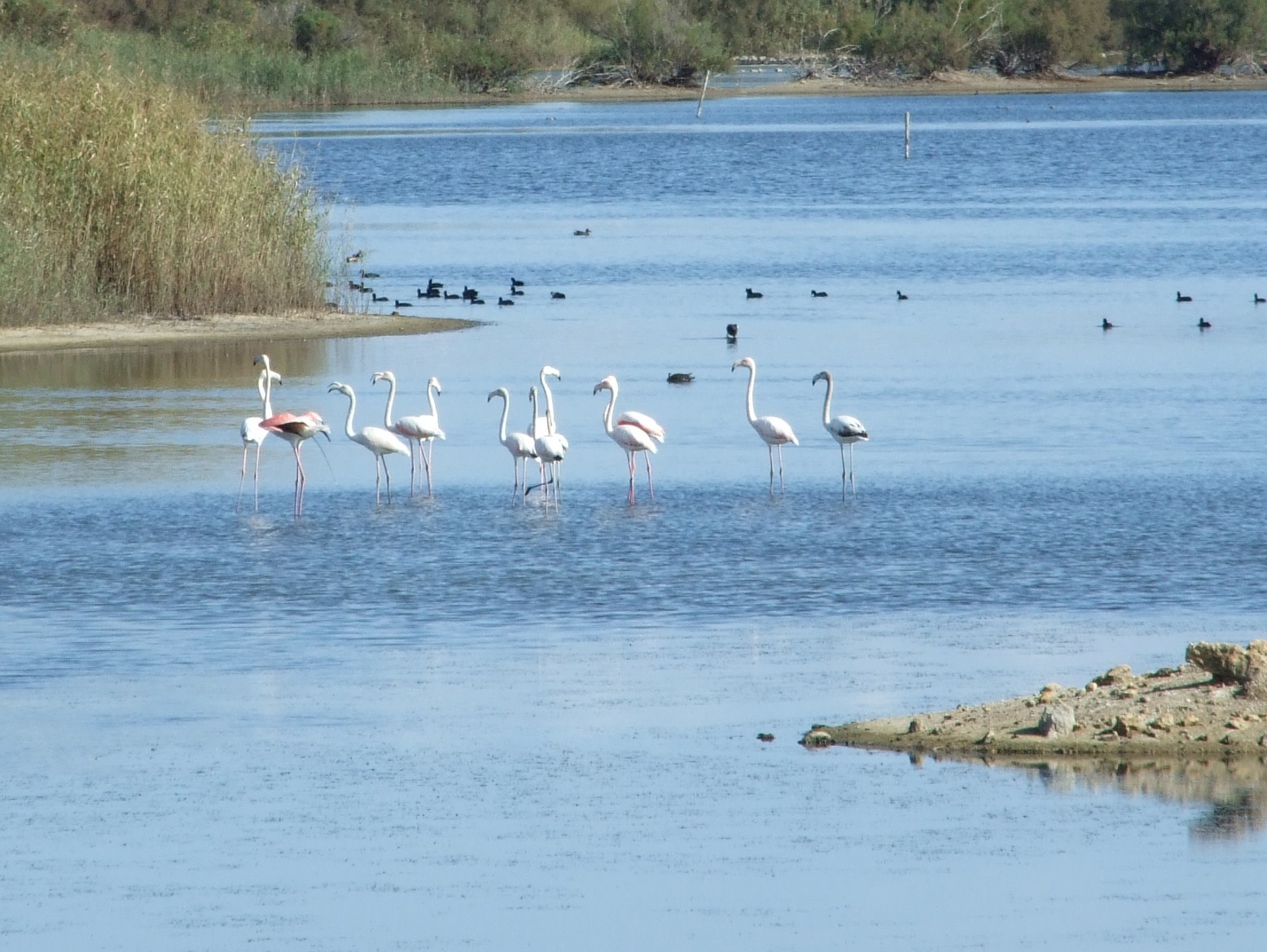
La région de Syracuse est riche en réserves naturelles.

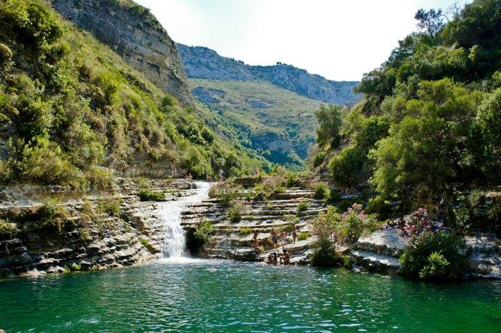
Cavagrande est l’une des régions les plus belles et les plus caractéristiques de Syracuse. Les vastes plates-formes karstiques des monts Iblei caractérisent le paysage de la pointe sud-est de la Sicile, à cheval sur les provinces de Ragusa et Syracuse. C’est surtout dans cette dernière que la plate-forme prend des aspects spectaculaires en raison de la présence de fractures profondes, appelées “carrières”, qui creusent les bords. Ce sont des canyons produits par l’érosion des cours d’eau qui coulent encore sur leur fond, parfois avec un aspect superbe comme dans le cas de la Cavagrande du Cassibile, l’un des plus majestueux et suggestifs, maintenant protégé comme réserve naturelle, était à l’époque paléolithique le site des établissements habités. Dans les murs il y a huit mille tombes rupestres en forme de grottes datant des Xe et IXe siècles av JC.
La Réserve Naturelle Cavagrande du Cassibile couvre une superficie d’environ 2.760 hectares dans les municipalités d’Avola, Noto et Syracuse. Elle a été créée en 1990 avec le but de protéger la végétation naturelle et de restaurer la forêt méditerranéenne ainsi que de défendre et augmenter la faune méditerranéenne.
Le territoire protégé comprend un parcours d’environ 10 km de la Cassibile, l’une des rivières les plus importantes du sud-est de la Sicile, qui s’enfonce fortement entre les rochers de la plate-forme d’Ibleo et génère un canyon, profond en certains endroits à plus de 250 mètres des parois abruptes à la végétation dense.

cavagrande del cassibile
I laghetti

Dans le territoire de la municipalité d’Avola (une charmante ville de la province de Syracuse), comme un diamant serti dans un bijou, il y a un petit paradis sur terre, un patrimoine naturel (historique et archéologique) de valeur incommensurable :
La Réserve naturelle orientée “Cava Grande del fiume Cassibile”. Une vallée, presque un canyon, où même les plus sécularisés, en visitant la réserve naturelle, retrouvent le goût de contempler les merveilles de la nature : flore (platane, saule, laurier-rose, lierre, fougère, etc.),
La faune (libellules, papillons colorés, boucles, renards, casquettes, coucous, crécerelles, etc,)
Les aspects géomorphologiques (nids-de-poule géants, lacs magnifiques, “marie”) et archéologiques (village byzantin, nécropole casbile, “Grottes des brigands”).
Il existe de nombreux sentiers qui permettent d’accéder à la réserve, vous permettant de visiter n’importe quel point de la vallée, de “Manghisi” à l’embouchure de la rivière. Et il y en a pour tous les goûts : pour les amateurs de promenades insouciantes à l’ombre d’un bosquet et pour ceux qui aiment les randonnées plus dures et plus difficiles, pour les amoureux du fond de la vallée et du paysage de montagne, pour les amoureux de la nature et de l’archéologie.

Prisa – Timpa ca Tona

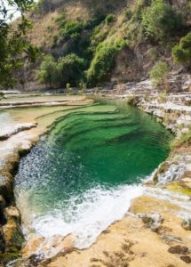
Dans cet itinéraire le randonneur a la possibilité de découvrir et d’admirer un lieu très suggestif, peu connu et qui n’a rien à envier aux célèbres lacs : “Timpa ca tona” (pierre qui fait écho). Le paysage se présente dans toute sa splendeur : un vaste plateau rocheux, un beau lac d’eau d’un vert cristallin, connu sous le nom de “uruvu tunnu” (lac rond), une végétation luxuriante, et une sorte de libellules parmi les plus belles et colorées d’Italie, qui en ce lieu semblent avoir implanté leur royaume, à admirer en glissant entre un oléandre et un autre. Suite à l’incendie de vastes proportions qui s’est produit le 25 juin 2014 et qui a détruit de nombreux hectares de végétation rendant les chemins dangereux, l’Azienda Foreste Demaniali, en tant que gestionnaire du Parc Naturel, a jugé opportun d’assurer la sécurité de ses usagers, fermer les chemins touchés directement ou indirectement par l’incendie : Scala Cruci, Scala di Mastra Ronna et Sentiero di Mezza Costa dans la section allant de Carrubella au Bassin collecteur ENEL.
Le seul sentier officiellement accessible est le sentier naturel “Prisa-Carrubella”, ou simplement “Carrubella”. Chaque jour, des milliers de touristes qui se rendent dans la réserve et qui ne connaissent pas l’Ordonnance de la Garde forestier, ils trouvent un accès fermé au sentier principal (Scala Cruci), mais la plupart du temps personne ne les avertit de l’existence du chemin mentionné ci-dessus et ouvert au public : le sentier Carrubella.
Avec la réalisation de cette page dans l’intérêt de la réserve elle-même et de l’image globale du territoire, nous, en tant qu’association naturaliste, appelée précisément “Cavagrande del Cassibile”, nous voulons combler, à notre manière, les graves lacunes qui découragent souvent les touristes de visiter les beautés du sud-est de la Sicile.

Comment accéder au sentier Carrubella

En arrivant à Avola, province de Syracuse, prendre la route provinciale n.4 Avola-Manghisi en suivant les indications pour Cavagrande del Cassibile (lacs). Sur une longueur d’environ 10 km, la route se déroule dans des virages qui montent dans les collines d’Avola Antica. Une fois que vous avez grimpé la colline, après avoir passé une résidence de villas, après environ 3 km vous atteignez la jonction qui mène au chemin principal, nommé Scala Cruci. Au carrefour, au lieu de tourner à droite, parce que vous n’arriveriez qu’au sentier principal fermé, continuez tout droit sur la route provinciale pendant encore 1300 mètres, puis tournez à droite au panneau touristique bien visible.
Un petit chemin de terre nous mène près du début du sentier de randonnée. Si vous avez de la chance, vous trouverez un parking public gratuit (il y en a très peu) sinon vous pouvez vous garer dans un parking payant géré par un concessionnaire.

http://www.cavagrandedelcassibile.it/foto_prisa_timpa_ca_tona/Prisa2.gif

L’itinéraire du trekking

En sortant de la voiture continuez vers l’arrière-pays en passant devant une exploitation agricole, un peu plus loin nous arrivons à un carrefour : sur la droite nous voyons un panneau et une cabane en bois, la cabane d’accueil du garde forestier.
Si vous voulez faire un petit tour sur le sentier de la Carrubella, prenez à droite et descendez progressivement dans le canyon. Ceux qui veulent faire le tour complet du sentier, à la bifurcation, continueront tout droit pendant encore 5-600 mètres, au bout d’un portail en bois et un panneau indique que nous sommes au début de la descente dans le canyon. Un escalier creusé dans la roche nous permettra en quelques centaines de mètres d’atteindre le niveau de la rivière, juste à l’endroit où au début du siècle dernier a été construit le barrage qui transportait une partie de l’eau de la rivière dans un aqueduc qui actionnait les turbines d’une centrale hydroélectrique située à la fin du canyon.
Le sentier serpente toujours à droite de la rivière à travers de beaux paysages pour la plupart à l’ombre des chênes, saules, chênes, chênes, aubépines, poires sauvages, lauriers roses, platanes orientaux ainsi qu’une végétation dense et luxuriante riparienne. Profitez de ce tronçon et ne soyez pas pressés d’aller au lac, surtout vous qui aimez la nature et vous n’êtes pas venus pour vous baigner dans les eaux fraîches de la Cassibile.
Après environ 15-20-25 minutes de marche vous arrivez à un carrefour : à droite commence la longue sortie du canyon et nous irons à gauche vers une source et le “Uruvu tunnu”. A quelques mètres et ouvre devant nous un scénario unique, le royaume des libellules colorées, une vaste plates-forme rocheuse où se trouvent les “marmite du diable ou marmite de géant”, dont celle du tunnu Uruvu, le rond lac où vous devez prendre un bain régénérateur et rafraichissant.
Quand vous décidez de retourner à votre voiture, retournez à la bifurcation et continuez à grimper le sentier qui vous mènera progressivement à la sortie, vers le refuge forestier situé à la bifurcation dont nous avons parlé plus tôt. Comme mentionné précédemment, théoriquement, ceux qui veulent juste atteindre le lac, au lieu de contourner le lac en passant par le barrage et les bois, peuvent descendre dans le canyon directement d’ici et remonter par la même route.

Conseils utiles

1. Porter des chaussures de randonnée ou de tennis (AVERTISSEMENT, vous ne pouvez pas entrer avec des chaussures ouvertes) ;
2. Le chemin est accessible de 8h00 à 19h00 ;
3. Il est obligatoire avoir de l’eau à boire (et, pourquoi pas, des sels minéraux) ;
4. Il est interdit d’amener des chiens même en laisse ou autres animaux de compagnie (art. 2 lett. n du règlement) ;
5. La route n’est as recommandée pour les personnes souffrant d’asthme, d’allergies respiratoires, cardiaques, d’allergies et les femmes enceintes ;
6. En cas de pluie, la réserve reste fermée pendant environ 2-3 jours ;
7. Dans la réserve, il n’y a pas de réseau de téléphonie mobile (les téléphones mobiles n’ont pas de la connexion) ;
8. Il est conseillé de descendre aux heures les plus fraîches (jusqu’à 9h00) et de remonter après 17h00 ;

Leave a Comment

0.0/5

The area of Syracuse is rich in nature reserves.

Cavagrande is one of the most beautiful and characteristic of the Syracuse area. The extensive karst planks of the Iblei Mountains characterize the landscape of the southeastern extremity of Sicily, between the provinces of Ragusa and Syracuse. It is especially in the latter that the plateau assumes spectacular aspects due to the presence of deep fractures, called “cave”, which furrow the edges. These are canyons produced by the erosion of watercourses that still flow on their bottom, sometimes with a superb appearance as in the case of the Cavagrande del Cassibile, one of the most majestic and suggestive, now protected as a nature reserve, was in the Paleolithic era the site of inhabited settlements. Eight thousand cave-like rock tombs dating back to the 10th and 9th centuries B.C. have been dug into the walls.
Established in 1990 in order to preserve the natural vegetation, and restore the Mediterranean forest vegetation as well as to defend and increase the Mediterranean fauna, the Nature Reserve Cavagrande del Cassibile extends over an area of about 2,760 hectares, falling in the municipalities of Avola, Noto and Syracuse. The protected area includes a stretch, about 10 km long, of the river shaft of the cassibile, one of the most important rivers in south-eastern Sicily, which, strongly embedded in the rocks of the Ibleo plateau, generates a canyon, some stretches over 250 meters deep, with steep walls thickly vegetated.

cavagrande del cassibile
I laghetti

Like a diamond set in a jewel, so in the territory of the Municipality of Avola (a charming town in the province of Syracuse) there is a corner of paradise on earth, a natural heritage (historical and archaeological) of immeasurable value:
the Riserva Naturale Orientata “Cava Grande del fiume Cassibile”. A valley, almost a canyon, where even the most secularized, visiting the nature reserve regain the taste to contemplate the wonders of nature: flora (plane tree, willow, oleander, ivy, fern, etc..),
fauna (dragonflies, colourful butterflies, curls, foxes, blackcap, cuckoo, kestrel, etc.),
geomorphological aspects (potholes, hints of erosion, splendid ponds, “marie”) and archaeological aspects (Byzantine village, necropolis of Cassibile, “grotta dei briganti”).
There are many paths that allow access to the reserve, allowing you to visit any point of the valley, from “Manghisi” to the estuary of the river. And there is something for everyone: for lovers of carefree walks in the shade of a grove and for those who love trekking harder and more challenging, for lovers of the valley floor and those of the mountain landscape, for lovers of nature and for those of archaeology.

Prisa – Timpa ca Tona

In this itinerary the hiker has the opportunity to discover and admire a very suggestive place, little known and that has nothing to envy to the famous lakes: “Timpa ca tona” (echoing stone). The landscape presents itself in all its splendor: a vast rocky plateau, a beautiful lake of crystal clear green water, known by the name “uruvu tunnu” (round lake), lush vegetation, and a kind of dragonflies among the most beautiful and colorful in Italy, which in this place seem to have implanted their kingdom, to be admired while gliding between an oleander and another. Following the large-scale fire that occurred on 25 June 2014 that destroyed many hectares of vegetation rendering the paths unsafe, the Azienda Foreste Demaniali, as manager of the Nature Reserve, considered it appropriate, to ensure the safety of its users, to close the paths directly or indirectly affected by the fire: Scala Cruci, Scala di Mastra Ronna and Sentiero di Mezza Costa in the stretch from Carrubella to the ENEL collection basin.
The only officially accessible path is the nature path “Prisa-Carrubella”, or simply Carrubella. Thousands of tourists, unaware of the ordinance of the Forestry, who daily visit the reserve will find the access to the main path (Scala Cruci) rightfully closed, but most of the time no one warns them of the existence of the path mentioned above and open to the public: the path Carrubella precisely.
With the realization of this page in the interest of the reserve itself and the overall image of the territory we as a naturalistic association, named in fact “Cavagrande del Cassibile”, we want in this way to fill the serious gaps that often discourage tourists from visiting the beauties present in the south-east of Sicily.

How to reach the Carrubella path

Once in Avola, province of Syracuse, follow the SP 4 Avola-Manghisi following the signs for Cavagrande del Cassibile (small lakes). The route winds its way through hairpin bends that climb the hills of Avola Antica for about 10 km. Once you have climbed the hill, after passing a residence of villas, after about 3 km you reach the junction that leads to the main path, namely Scala Cruci. At the crossroads instead of turning right, because you would only get to the main path closed, continue straight on the provincial road for some 1300 meters, then turn right at the clearly visible tourist sign.
A small dirt road leads to the beginning of the trekking path. If you are lucky you will find some free public parking (there are very few) otherwise you can park in a toll parking lot privately owned.
http://www.cavagrandedelcassibile.it/foto_prisa_timpa_ca_tona/Prisa2.gif

The trekking route

After leaving the car continue towards the hinterland passing in front of a farm, a little further on you will reach a junction: on the right you will see a sign and a wooden hut, the reception hut of the forester.
If you want to take a short tour of the Carrubella path, go right and gradually descend into the canyon. Those who want to make the complete tour of the path, at the fork, will continue straight for another 5-600 meters, at the end of a wooden gate and a sign indicates that we are at the beginning of the descent into the canyon. A staircase carved into the rock will allow you to reach the level of the river in a few hundred meters, just at the point where at the beginning of the last century was built the dam that conveyed part of the water of the river in an aqueduct that operated the turbines of a hydroelectric power plant located downstream at the end of the canyon.
The path always winds to the right of the river through beautiful landscapes for the most part in the shade of oaks, willows, hawthorns, wild pears, oleanders, oriental plane trees as well as a dense and lush vegetation riparian. Enjoy this stretch and do not be in a hurry to get to the lake, especially if you love nature and you have not come just to bathe in the cool waters of the Cassibile.
After about 15-20-25 minutes of walking you arrive at a fork: to the right begins the long exit from the canyon so you will turn left towards a source and the “Uruvu tunnu”. A few meters and opens in front of us a unique scenario, the kingdom of colorful dragonflies, a vast rocky plateau where they are set the “potholes of giants”, one of which is just the Uruvu tunnu, ie the round pond where a refreshing and regenerating bath is a must.
When you decide to go back to your car, go back to the fork and continue climbing up the path that will gradually take you to the exit, towards the forest hut located at the fork we talked about earlier. As previously mentioned, theoretically those who just want to reach the lake, instead of going around the lake passing through the dam and the woods, can go down into the canyon directly from here and go up again from the same road.

Useful advice

1 Wear hiking or tennis shoes (WARNING YOU CANNOT ACCESS THE PATH WITH OPEN-TOED SHOES);
2 The path is accessible from 8.00 a.m. to 7 p.m;
3 Bring some water to drink (and, why not, mineral salts);
4 It is forbidden to bring in dogs even if on a leash or other pets (art. 2 lett. n of the regulation);
5 The trail is not recommended for individuals with asthma, respiratory issues, heart, allergies and pregnant women;
6 In case of rain the reserve remains closed for about 2-3 days;
7 In the reserve there is no mobile phone network (mobile phones has no reception here);
8 It is advisable to descend during the fresher hours (until 9.00 a.m.) and ascend after 5.00 p.m.


Leave a Comment

0.0/5

La zona di Siracusa è ricca di riserve naturali.

Cavagrande è una delle più belle e caratteristiche della zona di Siracusa. Gli estesi tavolati carsici dei Monti Iblei caratterizzano il paesaggio dell’estremità sudorientale della Sicilia, a cavallo delle province di Ragusa e Siracusa. E’ soprattutto in quest’ultima che l’altopiano assume aspetti spettacolari per la presenza di profonde fratture, chiamate “cave”, che ne solcano i bordi. Si tratta di canyon prodotti dall’erosione dei corsi d’acqua che ancora scorrono sul loro fondo, dall’aspetto a volte superbo come accade nel caso della Cavagrande del Cassibile, una delle più maestose e suggestive, oggi tutelata come riserva naturale, fu in epoca paleolitica sede di insediamenti abitati. Nelle pareti sono state scavate ottomila tombe rupestri del tipo a grotticella, risalenti al X e IX secolo a.C…
Istituita nel 1990 al fine di conservare la vegetazione naturale, e ripristinarne la vegetazione forestale mediterranea nonchè di difendere e incrementare la fauna mediterranea, la Riserva naturale orientata Cavagrande del Cassibile interessa un’area vasta 2.760 ettari circa, ricadente nei comuni di Avola, Noto e Siracusa. L’area protetta ingloba un tratto, lungo circa 10 km, dell’asta fluviale del cassibile, uno dei più importanti fiumi della sicilia sud-orientale, che, incassandosi fortemente tra le rocce del tavolato ibleo, genera un canyon, profondo in alcuni tratti oltre 250 metri, dalle ripide pareti fittamente vegetate.

cavagrande del cassibile
I laghetti

Come un diamante incastonato in un gioiello, così nel territorio del Comune di Avola (una ridente cittadina della provincia di Siracusa) vi è un angolo di paradiso terrestre, un patrimonio naturalistico (storico ed archeologico) di incommensurabile valore:
la Riserva Naturale Orientata “Cava Grande del fiume Cassibile”. Una vallata, quasi un Canyon, dove anche i più secolarizzati, visitando la riserva naturale riacquistano il gusto di contemplare le meraviglie della natura: flora (platano, salice, oleandro, edera, felce, ecc.),
fauna (libellule, farfalle coloratissime, ricciolo, volpe, capinera, cuculo, gheppio, ecc.),
aspetti geomorfologici (marmitte dei giganti, docce di erosione, splendidi laghetti, “marie”) e archeologici (villaggio bizantino, necropoli del Cassibile, “grotta dei briganti”).
Numerosissimi sono i sentieri che permettono l’accesso alla riserva, consentendo così la visita di qualsiasi punto della vallata, da “Manghisi” fin alla foce del fiume. E ce n’è per tutti i gusti: per gli amanti di spensierate passeggiate all’ombra di un boschetto e per quelli appassionati di trekking più duro e impegnativo; per gli amanti del fondovalle e per quelli del panorama a monte; per gli amanti degli aspetti naturalistici e per quelli dell’archeologia.

Prisa – Timpa ca Tona

In questo itinerario l’escursionista ha la possibilità di scoprire ed ammirare un posto alquanto suggestivo, poco conosciuto e che non ha nulla da invidiare ai famosi Laghetti: “Timpa ca tona” (Pietra echeggiante). Il paesaggio si presenta in tutto il suo splendore: un vasto pianoro roccioso, un bel laghetto d’acqua verde cristallina, conosciuta con toponimo “uruvu tunnu” (Laghetto rotondo), una vegetazione lussureggiante, e una specie di libellule fra le più belle e colorate d’Italia, che in questo posto sembrano abbiano impiantato il loro regno, da ammirare mentre planano tra un oleandro e l’altro. In seguito all’incendio di vaste proporzioni verificatosi il 25 giugno del 2014 che ha distrutto moltissimi ettari di vegetazione rendendo i sentieri poco sicuri, l’Azienda Foreste Demaniali, in qualità di gestore della Riserva Naturale, ha ritenuto opportuno, per garantire l’incolumità dei suoi fruitori , chiudere i sentieri interessati direttamente o indirettamente dall’incendio: Scala Cruci, Scala di Mastra Ronna e Sentiero di Mezza Costa nel tratto da Carrubella alla Vasca di raccolta dell’ENEL.
L’unico sentiero ufficialmente fruibile è il sentiero natura “Prisa-Carrubella”, o semplicemente Carrubella. I migliaia di turisti, ignari dell’ordinanza della Forestale, che quotidianamente si recano alla riserva trovano giustamente chiuso l’accesso al sentiero principale (Scala Cruci), ma il più delle volte nessuno li avverte dell’esistenza del sentiero sopramenzionato e aperto al pubblico: il sentiero Carrubella appunto.
Con la realizzazione di questa pagina nell’interesse della riserva stessa e dell’immagine complessiva del territorio noi come associazione naturalistica, denominata appunto “Cavagrande del Cassibile, vogliamo nel nostro piccolo andare a colmare le gravi lacune che spesso scoraggiano i turisti nel visitare le bellezze presenti nel sud-est della Sicilia.

Come raggiungere il sentiero Carrubella

Giunti ad Avola, provincia di Siracusa, prendere la strada provinciale n.4 Avola-Manghisi seguendo le indicazioni per Cavagrande del Cassibile (laghetti). Per circa 10 km il percorso si snoda tra tornanti che si inerpicano nelle colline di Avola Antica. Una volta scollinati, oltrepassato un residence di villette, dopo circa 3 km si giunge al bivio che porta al sentiero principale, vale a dire Scala Cruci. Al bivio anziché svoltare a destra, perché si arriverebbe solamente al sentiero principale chiuso, proseguire dritto sempre nella strada provinciale per altri 1300 metri circa svoltando quindi a destra in corrispondenza del ben visibile cartello turistico.
Una stradina sterrata ci conduce nei pressi dell’inizio del percorso trekking. Se siete fortunati troverete qualche parcheggio pubblico libero (ce ne sono veramente pochi) altrimenti potete parcheggiare in un parcheggio a pagamento gestito da un privato.

http://www.cavagrandedelcassibile.it/foto_prisa_timpa_ca_tona/Prisa2.gif

Il percorso trekking

Lasciata l’auto si prosegue sempre verso l’entroterra passando davanti ad una fattoria, poco più avanti arriviamo ad un bivio: sulla destra notiamo un cartello e un capanno in legno, il capanno di accoglienza della forestale
Chi vuole fare un giro breve del sentiero Carrubella andrà a destra scendendo gradualmente nel canyon. Chi, invece vuole fare il giro completo del sentiero, al bivio, proseguirà dritto per altri 5-600 metri; in fondo un cancelletto in legno e un cartello ci segnala che siamo all’inizio della discesa nel canyon. Una scalinata intagliata nella roccia ci permetterà in poche centinaia di metri di giungere al livello del fiume, proprio nel punto in cui all’inizio del secolo scorso fu realizzata la diga che convogliava parte dell’acqua del fiume in un acquedotto che azionava le turbine di una centrale idroelettrica posta a valle nella parte terminale del canyon.
Il sentiero si snoda sempre alla destra del fiume passando in suggestivi paesaggi per buona parte all’ombra di lecci, salici, roverelle, biancospini, peri selvatici, oleandri, platani orientali oltre a una fittissima e rigogliosissima vegetazione ripariale. Godetevi questo tratto e non abbiate fretta di arrivare al laghetto, soprattutto voi che amate la natura e non siete venuti solo per fare il bagno nelle freschi acque del Cassibile.
Dopo circa 15-20-25 minuti di cammino arrivate ad un bivio: a destra inizia la lunga uscita dal canyon per cui andremo a sinistra verso una sorgente e l'”Uruvu tunnu”. Pochi metri e si apre davanti a noi uno scenario unico, il regno delle coloratissime libellule, un vasto pianoro roccioso dove sono incastonati le “marmitte dei giganti”, una delle quali è proprio l’Uruvu tunnu, vale a dire il laghetto rotondo dove è d’obbligo un rinfrescante e rigenerante bagno.
Nel momento in cui deciderete di tornare alle macchine tornate al bivio e proseguite salendo nel sentiero che gradualmente vi porterà verso l’uscita, verso il capanno della forestale posto al bivio di cui vi parlavamo prima. Come precedentemente detto, teoricamente chi vuole solo raggiungere il laghetto, anziché fare il giro largo passando dalla diga e dai boschi, può scendere nel canyon direttamente da qui e risalire dalla stessa strada.
Consigli utili
1° indossare scarpe da trekking o da tennis (ATTENZIONE NON POTETE ENTRARE CON SCARPE APERTE);
2° il sentiero è fruibile dalle ore 8,00 alle ore 19,00;
3° portare acqua da bere (e, perché no, sali minerali);
4° è vietato introdurre cani anche se al guinzaglio o altri animali domestici (art. 2 lett. n del regolamento);
5° percorso sconsigliato a individui con problemi d’asma, respiratori, cardiaci, d’allergia e donne in gravidanza;
6° in caso di pioggia la riserva rimane chiusa 2-3 giorni circa;
7° nella riserva non c’è rete di telefonia mobile (i cellulari non prendono);
8° si consiglia di scendere nelle ore più fresce (fino alle 9,00) e risalire dopo le 17,00;

Leave a Comment

0.0/5

Iscriviti alla Newsletter

Se vuoi saperne di più su come viaggiare, iscriviti alla mia newsletter gratuita piena di consigli e fantastiche idee di viaggio.

Prenota Ora